
The Ridge guidebook
Food scene
This is a list of some of my family's favorite Pagosa restaurants.
Alley House Grille
214 Pagosa StBest dinner in town
Sage Mobile Eatery
920 E Pagosa StGreat for lunch
Kip's Grill
121 E Pagosa Stgreat fish tacos
Great place to grab coffee and a souvenir. Conveniently located on the river walk for a stroll downtown.
26 lokale inwoners raden aan
ROOT HOUSE coffee + shop
445 San Juan StGreat place to grab coffee and a souvenir. Conveniently located on the river walk for a stroll downtown.
Currently offering "to-go" and is a great place to grab a meal.
39 lokale inwoners raden aan
Thai Pagosa
565 Village DrCurrently offering "to-go" and is a great place to grab a meal.
The best food ever! Reservations highly recommended, make yours on 'open table'.
Meander Riverside Eatery
The best food ever! Reservations highly recommended, make yours on 'open table'.
Hikes in the area
Rainbow Hot Springs is a 10 mile heavily trafficked out and back trail located near Pagosa Springs, Colorado that features a waterfall and is rated as moderate. The trail offers a number of activity options and is best used from June until September. Dogs are also able to use this trail but must be kept on leash.
Directions to Trailhead:
Take Highway 160 (towards Wolf Creek Pass) about 16 miles until you see a sign for West Fork Campground (just before you get to Treasure Falls). Take West Fork Campground Rd. (CR-648) about 7 miles to West Fork Trailhead (follow the sign that points to West Fork Campground 1.0 mile - don't follow 648A or 648B).
Directions to Rainbow Hot Springs:
(West Fork Trail-561) From the parking lot to the first campsite I found it was 7.56 miles. From the parking lot you will follow a jeep road passing several private residences. The beginning of the trail is marked very well to warn you where property lines are. The jeep road ends 0.2 miles in and you will follow the trail along West Fork Canyon. The sign for Weminuche Wilderness is 2.36 miles in. From this sign you will go 0.07 miles to the first of 3 man-made bridges. From this bridge you will go 1.72 miles where you will see a waterfall to the left and a water crossing. From the waterfall you will go 0.41 miles to the 2nd man-made bridge. Another 0.25 miles and you will cross the 3rd man-made bridge and see a sign marked ‘Main Trail’. Stay on the main trail which will take you 200ft. up the east side of the canyon. Another 1.0 mile and keep your eyes peeled for the Beaver Creek Trail sign on the right side of the trail (it was closed when I went). Stay on the main trail. You should cross 3 or 4 drainages (the first may be dried up depending on the rainfall). The last drainage is fed by a waterfall to your right. Continue to follow the trail up the hill until the trail forks. Follow the trail to the left where you will see the first campsite (fire ring and 2 log benches). The campsite sits right on the edge of the canyon and oversees the hot springs and river. There is a steep trail from the campsite that takes you down to the hot springs.
10 lokale inwoners raden aan
Rainbow Hot Springs
Rainbow Hot SpringsRainbow Hot Springs is a 10 mile heavily trafficked out and back trail located near Pagosa Springs, Colorado that features a waterfall and is rated as moderate. The trail offers a number of activity options and is best used from June until September. Dogs are also able to use this trail but must be kept on leash.
Directions to Trailhead:
Take Highway 160 (towards Wolf Creek Pass) about 16 miles until you see a sign for West Fork Campground (just before you get to Treasure Falls). Take West Fork Campground Rd. (CR-648) about 7 miles to West Fork Trailhead (follow the sign that points to West Fork Campground 1.0 mile - don't follow 648A or 648B).
Directions to Rainbow Hot Springs:
(West Fork Trail-561) From the parking lot to the first campsite I found it was 7.56 miles. From the parking lot you will follow a jeep road passing several private residences. The beginning of the trail is marked very well to warn you where property lines are. The jeep road ends 0.2 miles in and you will follow the trail along West Fork Canyon. The sign for Weminuche Wilderness is 2.36 miles in. From this sign you will go 0.07 miles to the first of 3 man-made bridges. From this bridge you will go 1.72 miles where you will see a waterfall to the left and a water crossing. From the waterfall you will go 0.41 miles to the 2nd man-made bridge. Another 0.25 miles and you will cross the 3rd man-made bridge and see a sign marked ‘Main Trail’. Stay on the main trail which will take you 200ft. up the east side of the canyon. Another 1.0 mile and keep your eyes peeled for the Beaver Creek Trail sign on the right side of the trail (it was closed when I went). Stay on the main trail. You should cross 3 or 4 drainages (the first may be dried up depending on the rainfall). The last drainage is fed by a waterfall to your right. Continue to follow the trail up the hill until the trail forks. Follow the trail to the left where you will see the first campsite (fire ring and 2 log benches). The campsite sits right on the edge of the canyon and oversees the hot springs and river. There is a steep trail from the campsite that takes you down to the hot springs.
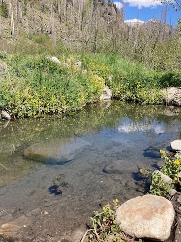
The amount and condition of pools to soak in depends upon the environment and individual upkeep. You will often find evidence of hot springs visitors digging new hot springs pools to soak in.
The pools are built by stacking stones to block out the cold river water and then feeding in the hot springs, full of restorative minerals. Most average around 100°F, while some report 107°F
Directions to the trail head:
Take US-160 for about 20 miles south of Pagosa Springs. Just past the Chimney Rock turnoff on the left, make a right onto 1st Fork Rd/Co Rd 166/Usfs 622. (First Fork Road follows the Piedra River.)
Follow this dirt road for 6.7 miles to the intersection of Monument Park Road and a parking area. Take the Sheep Creek Trailhead.
It is a 3 mile round trip hike to the Piedra River Hot Springs. Follow the trail for about 1.5 miles until you reach the hot springs. A half mile into the downhill hike, you’ll reach a fork in the road. Left takes you over a bridge, and right continues to the hot springs. Go right.
The hot springs are located in the San Juan National Forest.

Piedra River Hot Springs
The amount and condition of pools to soak in depends upon the environment and individual upkeep. You will often find evidence of hot springs visitors digging new hot springs pools to soak in.
The pools are built by stacking stones to block out the cold river water and then feeding in the hot springs, full of restorative minerals. Most average around 100°F, while some report 107°F
Directions to the trail head:
Take US-160 for about 20 miles south of Pagosa Springs. Just past the Chimney Rock turnoff on the left, make a right onto 1st Fork Rd/Co Rd 166/Usfs 622. (First Fork Road follows the Piedra River.)
Follow this dirt road for 6.7 miles to the intersection of Monument Park Road and a parking area. Take the Sheep Creek Trailhead.
It is a 3 mile round trip hike to the Piedra River Hot Springs. Follow the trail for about 1.5 miles until you reach the hot springs. A half mile into the downhill hike, you’ll reach a fork in the road. Left takes you over a bridge, and right continues to the hot springs. Go right.
The hot springs are located in the San Juan National Forest.
The first two miles of the Little Blanco Trail are steep and winding. The trail enters the South San Juan Wilderness area at 2.5 miles. Follow the trail 1/2 mile to the junction of the Quartz Lake Trail. The Quartz Creek Trail continues to the left for 1 mile north to Quartz Lake, at 11,600 feet. The lake itself is relatively small, but pristine. The Little Blanco Trail continues northeast four miles to the Continental Divide. The highest point is at 12,246 feet.
Quartz Lake
The first two miles of the Little Blanco Trail are steep and winding. The trail enters the South San Juan Wilderness area at 2.5 miles. Follow the trail 1/2 mile to the junction of the Quartz Lake Trail. The Quartz Creek Trail continues to the left for 1 mile north to Quartz Lake, at 11,600 feet. The lake itself is relatively small, but pristine. The Little Blanco Trail continues northeast four miles to the Continental Divide. The highest point is at 12,246 feet.
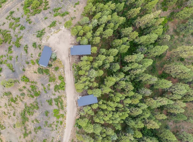
Hiking trails are just outside your door! From the top parking area near the cabins, look for small orange marking flags to start hiking the ridge line. Walk approx 200 yards and you will see a cattle fence.
If you turn to the right you will follow a well established trail for 1.15 miles and will end on the driveway below the cabins.
or
If you turn to the left you can go through the green cattle gate (please close behind you). Continue on the driveway beyond the gate until it ends, then turn to your left and continue hiking up hill until you get to the top.
330 Fritz and Mable's Pl
330 Fritz and Mable's PlaceHiking trails are just outside your door! From the top parking area near the cabins, look for small orange marking flags to start hiking the ridge line. Walk approx 200 yards and you will see a cattle fence.
If you turn to the right you will follow a well established trail for 1.15 miles and will end on the driveway below the cabins.
or
If you turn to the left you can go through the green cattle gate (please close behind you). Continue on the driveway beyond the gate until it ends, then turn to your left and continue hiking up hill until you get to the top.
This trail is a section of the Continental Divide Trail #813 and is a very popular hike with great views of Wolf Creek Ski Area, Alberta Reservoir and the East Fork Valley. The trails starts by heading south and east from the Great Continental Divide display atop Wolf Creek Pass. Hike across the meadow and cross the bridge on the far side. Turn left immediately after crossing the bridge and stay left going up through the trees. The trail switchbacks up through the conifer forest for the first mile, with the Wolf Creek Ski area on your left and often a rocky talus slope on your right, referred to as “the Rock Garden”. At the top of the rock garden you encounter the top of the Bonanza Chair Lift, keep right as the trail enters the trees again. Along this section you will encounter the Treasure Pass trail going off steeply downhill on your right. At 2.1 miles the trail emerges from the trees and contours around the top of a steep bowl on your right. From here there are views down into the East Fork Valley. The trail will then bear left and come out on top of a ridge that is the top of the ski area. Follow the trail across the ridge to the base of Alberta Peak . The CDT goes around the peak to the right but the peak may be summited by scrambling up its rocky slope to the top at 11,870′ elevation. The summit provides a great lunch spot with unbelievable views in all directions.
Drive west on Highway 160 for 22.9 miles till you reach top of Wolf Creek Pass. The large parking lot will be on the right next to Continental Divide Display sign.
Alberta Peak
This trail is a section of the Continental Divide Trail #813 and is a very popular hike with great views of Wolf Creek Ski Area, Alberta Reservoir and the East Fork Valley. The trails starts by heading south and east from the Great Continental Divide display atop Wolf Creek Pass. Hike across the meadow and cross the bridge on the far side. Turn left immediately after crossing the bridge and stay left going up through the trees. The trail switchbacks up through the conifer forest for the first mile, with the Wolf Creek Ski area on your left and often a rocky talus slope on your right, referred to as “the Rock Garden”. At the top of the rock garden you encounter the top of the Bonanza Chair Lift, keep right as the trail enters the trees again. Along this section you will encounter the Treasure Pass trail going off steeply downhill on your right. At 2.1 miles the trail emerges from the trees and contours around the top of a steep bowl on your right. From here there are views down into the East Fork Valley. The trail will then bear left and come out on top of a ridge that is the top of the ski area. Follow the trail across the ridge to the base of Alberta Peak . The CDT goes around the peak to the right but the peak may be summited by scrambling up its rocky slope to the top at 11,870′ elevation. The summit provides a great lunch spot with unbelievable views in all directions.
Drive west on Highway 160 for 22.9 miles till you reach top of Wolf Creek Pass. The large parking lot will be on the right next to Continental Divide Display sign.
Pagosa Activities
The Pagosa Hot Springs resort is a local favorite. They offer different tubs at various temperatures. Snacks and drinks are available for purchase at the resort.
35 lokale inwoners raden aan
Hot Springs
The Pagosa Hot Springs resort is a local favorite. They offer different tubs at various temperatures. Snacks and drinks are available for purchase at the resort.
The hot air balloon ride is a wonderful way to see the sights.
6 lokale inwoners raden aan
Rocky Mountain Balloon Adventures
100 Village DrThe hot air balloon ride is a wonderful way to see the sights.
Overlook Hot Springs
432 Pagosa StThe overlook offer hot spring tubs to visitors.
A well defined and clearly labeled course is easy to find on Rez hill. Disc rentals are available at Pagosa Mountain Sports.
Reservoir Hill Disc Golf Course
A well defined and clearly labeled course is easy to find on Rez hill. Disc rentals are available at Pagosa Mountain Sports.
Pagosa Mountain Sports
162 Pagosa StBest place to rent bikes or sleds in town
The best spot to rent winter ski gear. They also have snow shoes and cross country equipment.
26 lokale inwoners raden aan
Ski & Bow Rack
354 E Pagosa StThe best spot to rent winter ski gear. They also have snow shoes and cross country equipment.
Reizigersadvies
Wat je moet meenemen
Don't forget sunscreen
At higher elevations it is important to wear sunscreen!
Nuttige zinnen
Drink lots of water!
Welcome to 7,250 ft elevation. Enjoy the views but drink a lot of water to avoid altitude sickness and make the most of your visit.